THE STORY OF WILLEM BARENTSZ ON NOVAYA ZEMLYA
Willem Barentsz a Dutch navigator, explorer and cartographer; short for “Barents zoon,” meaning Barents son, was born around 1550 on the island Terschelling in the Netherlands. In the 16th century he was navigator of three early expeditions to the North Pole. He sailed to Spain and the Mediterranean to complete an atlas of this region. He published this atlas with his comrad Petrus Plancius. The Barents Sea was formerly known as “Murmanskoye More” or the “Sea of Murmans” (Norwegians). Even the Dutch Cornelis Roule sailed over the Barents Sea to reach the islands in 1675.
Sailors call this part of the ocean “The Devil’s Dance Floor” due to its unpredictability, rapid currents, freezing weather and dangerous ice floes.
On his first adventure Willem Barentsz sailed all the way with three vessels to the West Coast of Novaya Zemlya. The goal of his journey was to find a passage to Asia for trading purposes with China. In 1594 they discovered the Orange Islands. The next year Prince Maurice of Orange was destined to discover more of the islands and planned a new expedition also led by Barentsz. The crew sailed with six ships and a cargo of goods for trade with China between the Siberian Coast and Vaygach Island. A bit further they found out that the Kara Sea was frozen. They returned without finding many crystals or Chinese people.


A third trip was organised in 1596; with ship the “Witte Swaen,” Willem Barentsz discovered Spitsbergen and Bear Island. This island was named Bear Island because they got attacked by many polar bears. Jacob van Heemskerck captained the first ship with Barentsz as navigator. They couldn’t reach Franz joseph Land with the wooden vessel because of ice floes. They sailed back to Bear Island to plan a new route. The two ships then split up to find the quickest way to China.
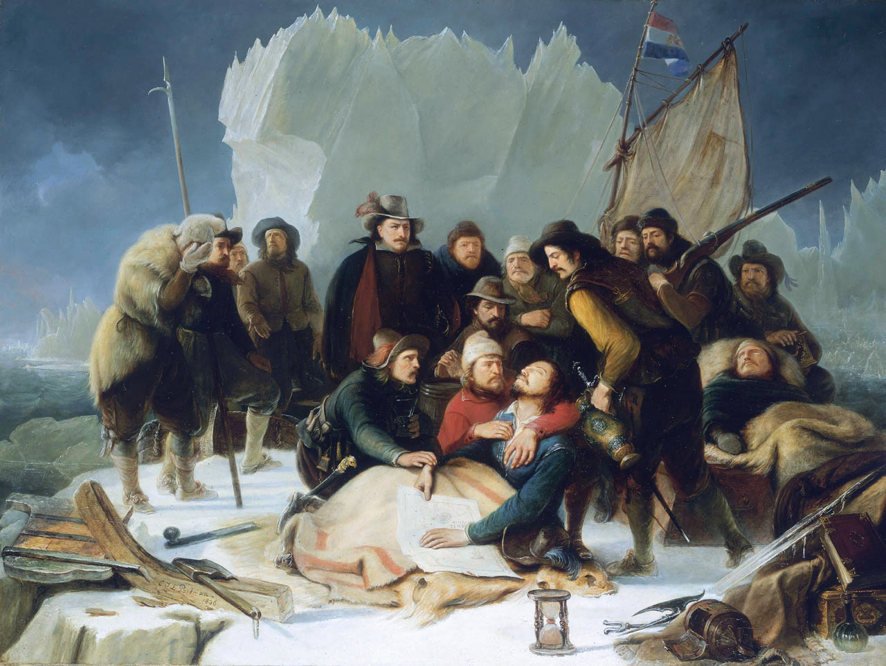
With his ship and a crew the great navigator stranded on the Orange Islands again. As he continued his journey the wooden ship got stuck in the ice floes on the East coast of Novaya Zemlya, began to lift up and started to crack.
Men and supplies had to be halted with smaller boats on to the nearest land where they stayed for the winter. The crew started to build a post from the driftwood they gathered and set up a camp on Novaya Zemlya ” ‘T Behouden Huys,” The Kept House. They tried to survive with the rations they took aboard, making clothes from fabric and making fire from shipwreckage, using hot canonballs to stay warm.
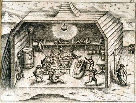
In the end there was a shortage of beer and bread. The barrels of beer they took seemed to have brast due to freezing. They tried to survive fighting polar bears and hunting snow foxes to get more vitamin C to prevent scurvy. In January the crew notices a strange anomaly in the sky wich they called the Novaya Zemlya effect.
A year later, on June 20th 1597 Willem Barentsz dies at sea. The remaining crew members including Van Heemskerck, Gerrit de Veer & Jan Huygen van Linschoten who suffered from scurvy were al picked up by Jan Cornelisz Rijp. A few men died during the escape from Novaya zemlya.
Sixteen men returned alive. The sea over which Barentsz sailed was named after him. A town on Spitsbergen archipelagos (Svlbard) called Barentszburg, in russian Баренцбург, still bears his name. In the year 1920 lots of Dutch, Norwegian and Russian mining settlements were founded there to carry out coalmining operations.

ROBBERTSZ’ STAR SONG
When they got back to Amsterdam on 1 November 1597, De Veer, Van Heemskerk and their teacher and maritime expert Robbert Robbertsz Le Canu who taught sailing skills at a school in Amsterdam got into an argument about the Novaya Zemlya effect which caused a breakup between the men. Robbert who delivered the Captains with maps and astronomical instruments couldn’t accept the fact that the sun had gone down two weeks earlier. In his astronomical measurements this effect did not exist.
In 1563, Robbert Robbertsz Le Canu was born in Amersfoort as the son of a baptist church servant.
The meaning of “canu” redirected from “sugar cane” is: “to sing or to chant”
Le Canu was a poet and maritime expert and moved to Amsterdam in 1586 to become a school teacher.
In the eyes of his students Robbert was a very knowledgeable and belligerent person who at that time rebelled against, errors in protestant churches. By focusing on maritime topics and seafaring in his lessons, he quickly gained the commitment of many students: Cornelis de Houtman, Jacob van Heemskerck, Gerrit de Veer, Jan Cornelisz Rijp and Jacob Cornelisz van Neck among them, learned their sailing skills from him.
Robbert was very keen on teaching his students to keep track of a sailing journal and to note the events that had happend from day to day.
Due to his knowledge as a mathematician and astrological expert he became a very popular teacher at his school in Amsterdam, which he attended from 1586 until he moved to Hoorn in 1611.
He played a very big part in spreading navigational technology and nautical principals and was a fellow countryman of Petrus Plancius, Snellius, and Jodocus Hondius and at that time renowned for being professor of grand seafaring. Le Canu provided maps of sea routes and astronomical equipment such as the nocturnal (instrument) and astrolabe. He was renowned for teaching his students navigational skills by looking at the night sky and stars.
He even wrote a song for the sailors to memorize the time of day during the dark arctic winters:
THE STAR SONG
A song to keep track of the time at night. Composed by Robbert Robbertsz for the benefits of his students.
A poem about how the hours of night,
link to all off the stars that are clearly in sight.
If you see one down South then you’ll know,
This song will tell you what time it is, so.
When the stars are standing in line,
distance about half an hour in time.
A star sign or twelve will go by in this tune,
where the sun is now at it will surely be noon.
Two stripes ahead shall be then one ‘o clock,
Count four this makes two when you just add them up.
Spot a bright shining star that glitters down South,
You’ll know what the rules of our time are about.
These three verses hereby just declared,
how this song should be liked distributed and shared.
Robbert had a wild and lively way of writing. In 1611 he sought refugee in Hoorn where he met Pieter Jansz Liorne.
Pieter who was known for helping design a much slimmer and unarmed ship then the Dutch “Fluyt” in 1595. He was a trustee, patron and mayor of Hoorn. He build a house for Robbert on “‘t Baatland” where he sold brandy until he past away in 1632.
Jan Huygen reproduced some Portugese maps and wrote a book “Itinerario.” He was a Dutch merchant, writer, accountant and drawing artist. His books contained a lot of information about the routes to sail to the Far East. This information was later used by the British East-Indian Company.
A childrens song was written about him called “Jan Huygen in de ton.”
Gerrit de Veer kept a journal about the journey and wintering in “The Kept House.” He named it:
(In English)
“The true and perfect description of three voyages so strange and wonderful, which have never been heard of before: done and performed three years, one after another, by the ships of Holland and Zeeland, on the north sides of Norway, Moscovia, and Tartaria, towards the kingdoms of Cathaia & China, as well as the experiences from the Weygates, Nova Zemlya, and from the land on 80 degrees, what people think is Greenland.”
(In Dutch)
“Waerachtighe Beschrijvinghe van drie seylagien, ter werelt noyt soo vreemt ghehoort, drie jaren achter malcanderen deur de Hollandtsche ende Zeelandtsche schepen by noorden, Noorweghen, Moscovia, ende Tartaria, na de coninckrijcken van Catthay ende China, so mede vande opdoeninghe vande Weygats, Nova Sembla, eñ van ‘t landt op de 80 gradẽ, dat men acht Groenlandt te zijn.” by Gerrit de Veer from Amsterdam,” published by Cornelis Claesz in 1598.
Cornelis Claesz was a publisher who started out selling books in Enkhuizen in 1578 and moved to Amsterdam. He specialized in maps and sea route descriptions and also published the works of Jehan Cauvin/ John Calvin and the travel journals of Jan Huygen van Linschoten in 1595/1596.
Van Linschoten received secret routes from the Portuguese and copied these and made sea maps of the Far East when he stayed in Goa.
These texts were of great importance to the VOC merchants. In his “Travel journals from the navigation of the Portugese in Oriental habitats” / “Reys-gheschrift van de navigatien der Portugaloysers in Orienten” and the “Itinerario Sailing Voyage of Jan Huygen Van Linschoten to East or Portugese India” / “Itinerario, Voyage orte schipvaert van Jan Huygen van Linschoten naer Oost ofte Portugaels Indien,” he described the routes to sail to China, Indonesia and Japan. This Dutch cultural heritage, some very accurate descriptions and many paintings from historical VOC figures and drawings about the journey to Novaya Zemlya are still on display in the Rijksmuseum Amsterdam.


THE VOC & WOOD DISTRIBUTION LINES
The VOC was a trading firm wich sailed to The Cape Of Good Hope and Asian trading routes to trade products, spices and accumulate slaves. They had a huge monopoly in this area, provided a million Europeans jobs and maintained almost 5000 vessels. The wood to build these ships was supplied from Germany over the river “Rijn,” Scandinavia and the Baltic Sea Coast. Because of hardness and durability oak wood was used for the heavy construction components of the ships.
For other parts such as masts and deck parts the lighter pine was used.
The United East India Company in Dutch “de Verenigde Oostindische Compagnie was a chartered company established by the States General of the Netherlands. They made a big profit from the Malukan spice trade. In 1609 the VOC established a capital in the port city of Jayakarta and named it “Batavia” better known today as Jakarta.
The territory that was owned by the VOC was named the Dutch East Indies and expanded with the Indonesian archipelago in the 19th century.
Harbor cities like Amsterdam, Hoorn, Enkhuizen, Delft, Rotterdam and Middelburg were VOC cities where plenty of goods arrived in these ports and lots of wood was distributed to build ships.


References & External
links
★ ᵂⁱᵏⁱᵐᵉᵈⁱᵃ ᶠᵒᵘⁿᵈᵃᵗⁱᵒⁿ ᴵⁿᶜ. “ᴴᵉⁿᵏ ᴱᵗⁱᵉⁿⁿᵉ.” ᵂⁱᵏⁱᵖᵉᵈⁱᵃ, ²⁸ ᴰᵉᶜᵉᵐᵇᵉʳ ²⁰²², cʳᵉᵃᵗⁱᵛᵉ cᵒᵐᵐᵒⁿˢ ᴬᵗᵗʳⁱᵇᵘᵗⁱᵒⁿ⁻sʰᵃʳᵉᴬˡⁱᵏᵉ ᴸⁱᶜᵉⁿˢᵉ ⁴.⁰..
★ ᵂⁱᵏⁱᵐᵉᵈⁱᵃ ᶠᵒᵘⁿᵈᵃᵗⁱᵒⁿ ᴵⁿᶜ. “ᵂⁱˡˡᵉᵐ ᴮᵃʳᵉⁿᵗˢᶻ.” ᵂⁱᵏⁱᵖᵉᵈⁱᵃ, ¹⁰ ᴶᵘⁿᵉ ²⁰²³, cʳᵉᵃᵗⁱᵛᵉ cᵒᵐᵐᵒⁿˢ ᴬᵗᵗʳⁱᵇᵘᵗⁱᵒⁿ⁻sʰᵃʳᵉᴬˡⁱᵏᵉ ᴸⁱᶜᵉⁿˢᵉ ⁴.⁰..
★ ᵂⁱᵏⁱᵐᵉᵈⁱᵃ ᶠᵒᵘⁿᵈᵃᵗⁱᵒⁿ ᴵⁿᶜ. “ᴮᵃʳᵉⁿᵗˢᵇᵘʳᵍ.” ᵂⁱᵏⁱᵖᵉᵈⁱᵃ, ²⁴ ᴬᵖʳⁱˡ ²⁰²³,cʳᵉᵃᵗⁱᵛᵉ cᵒᵐᵐᵒⁿˢ ᴬᵗᵗʳⁱᵇᵘᵗⁱᵒⁿ⁻sʰᵃʳᵉᴬˡⁱᵏᵉ ᴸⁱᶜᵉⁿˢᵉ ⁴.⁰..
★ ᵂⁱᵏⁱᵐᵉᵈⁱᵃ ᶠᵒᵘⁿᵈᵃᵗⁱᵒⁿ ᴵⁿᶜ. “ᴶᵃⁿ ᴴᵘʸᵍᵉⁿ ᵛᵃⁿ ᴸⁱⁿˢᶜʰᵒᵗᵉⁿ.” ᵂⁱᵏⁱᵖᵉᵈⁱᵃ, ⁵ ᴶᵘⁿᵉ ²⁰²³,cʳᵉᵃᵗⁱᵛᵉ cᵒᵐᵐᵒⁿˢ ᴬᵗᵗʳⁱᵇᵘᵗⁱᵒⁿ⁻sʰᵃʳᵉᴬˡⁱᵏᵉ ᴸⁱᶜᵉⁿˢᵉ ⁴.⁰.
★ ᵂⁱᵏⁱᵐᵉᵈⁱᵃ ᶠᵒᵘⁿᵈᵃᵗⁱᵒⁿ ᴵⁿᶜ. “cᵒʳⁿᵉˡⁱˢ cˡᵃᵉˢᶻ ⁽ᵈʳᵘᵏᵏᵉʳ⁾.” ᵂⁱᵏⁱᵖᵉᵈⁱᵃ, ¹⁸ ᴶᵘⁿᵉ ²⁰²³, cʳᵉᵃᵗⁱᵛᵉ cᵒᵐᵐᵒⁿˢ ᴬᵗᵗʳⁱᵇᵘᵗⁱᵒⁿ⁻sʰᵃʳᵉᴬˡⁱᵏᵉ ᴸⁱᶜᵉⁿˢᵉ ⁴.⁰.
★ ᵂⁱᵏⁱᵐᵉᵈⁱᵃ ᶠᵒᵘⁿᵈᵃᵗⁱᵒⁿ ᴵⁿᶜ. “ᴺᵒᵛᵃʸᵃ Zᵉᵐˡʸᵃ.” ᵂⁱᵏⁱᵖᵉᵈⁱᵃ, ²⁹ ᴶᵘⁿᵉ ²⁰²³, cʳᵉᵃᵗⁱᵛᵉ cᵒᵐᵐᵒⁿˢ ᴬᵗᵗʳⁱᵇᵘᵗⁱᵒⁿ⁻sʰᵃʳᵉᴬˡⁱᵏᵉ ᴸⁱᶜᵉⁿˢᵉ ⁴.⁰.
★ ᵂⁱᵏⁱᵐᵉᵈⁱᵃ ᶠᵒᵘⁿᵈᵃᵗⁱᵒⁿ ᴵⁿᶜ. ” ᴰᵘᵗᶜʰ ᴱᵃˢᵗ ᴵⁿᵈⁱᵃ ᶜᵒᵐᵖᵃⁿʸ.” ᵂⁱᵏⁱᵖᵉᵈⁱᵃ, ⁸ ᴶᵘˡʸ ²⁰²³, cʳᵉᵃᵗⁱᵛᵉ cᵒᵐᵐᵒⁿˢ ᴬᵗᵗʳⁱᵇᵘᵗⁱᵒⁿ⁻sʰᵃʳᵉᴬˡⁱᵏᵉ ᴸⁱᶜᵉⁿˢᵉ ⁴.⁰.
★ Fʳᵃⁿˢ ᴷʷᵃᵃᵈ. ” ᴿᵒᵇᵇᵉʳᵗ ᴿᵒᵇᵇᵉʳᵗˢᶻ ᴸᵉ cᵃⁿᵘ ⁽¹⁵⁶³⁻¹⁶³²⁾, ᴴᵒᵒʳⁿˢ ᵇⁱᵒᵍʳᵃᶠⁱˢᶜʰ ʷᵒᵒʳᵈᵉⁿᵇᵒᵉᵏ.” ⱽᵉʳᵉⁿⁱᵍⁱⁿᵍ ᴼᵘᵈ ᴴᵒᵒʳⁿ, ₂₆ ᴶᵘⁿᵉ ₂₀₁₆.
★ ᴿᵒᵇ ᴴ. ⱽᵃⁿ ᴳᵉⁿᵗ’ ⁽ʷⁱᵗʰ ᵗʰᵉ ᶜᵒˡˡᵃᵇᵒʳᵃᵗⁱᵒⁿ ᵒᶠ ᴿᵘᵈᵒˡᶠ ᴿᵃˢᶜʰ⁾. “ᴴᵉᵗ ˢᵗᵉʳʳᵉⁿˡⁱᵉᵈ ⁱⁿ ʰᵉᵗ ᴴᵒˡˡᵃⁿᵈˢᵉ ᶻᵉᵉᵛᵃᵃʳᵗ⁻ᵒⁿᵈᵉʳʷⁱʲˢ. ᴮᵉʳⁱʲᵐᵈᵉ ⁱⁿˢᵗʳᵘᶜᵗⁱᵉˢ ᵛᵒᵒʳ ʰᵉᵗ ᵛⁱⁿᵈᵉⁿ ᵛᵃⁿ ᵈᵉ ˢᵗᵉʳʳᵉⁿᵇᵉᵉˡᵈᵉⁿ ᵉⁿ ʰᵉᵗ ᵘᵘʳ ᵛᵃⁿ ᵈᵉ ⁿᵃᶜʰᵗ.”
ᵁᵗʳᵉᶜʰᵗ ᵁⁿⁱᵛᵉʳˢⁱᵗʸ ᴿᵉᵖᵒˢⁱᵗᵒʳʸ, ₂₀₀₅. ʰᵗᵗᵖˢ://ʷʷʷ.ᵒᵘᵈʰᵒᵒʳⁿ.ⁿˡ/ᵇⁱᵒᵍʳᵃᶠⁱᵉ/ᵈᵃᵗᵃ/ᵇⁱᵒᵍʳᵃᶠⁱᵉʳᵒᵇᵇᵉʳᵗʳᵒᵇᵇᵉʳᵗˢᶻˡᵉᶜᵃⁿᵘ_ˢᵗᵉʳʳᵉⁿˡⁱᵉᵈ.ᵖᵈᶠ. cʳᵉᵃᵗⁱᵛᵉ cᵒᵐᵐᵒⁿˢ ᴬᵗᵗʳⁱᵇᵘᵗⁱᵒⁿ⁻sʰᵃʳᵉᴬˡⁱᵏᵉ ᴸⁱᶜᵉⁿˢᵉ ³.⁰..
★ ᵂⁱᵏⁱᵐᵉᵈⁱᵃ ᶠᵒᵘⁿᵈᵃᵗⁱᵒⁿ ᴵⁿᶜ. “ᴰᵘᵗᶜʰ Fˡᵘʸᵗ.” ᵂⁱᵏⁱᵖᵉᵈⁱᵃ, ⁹ ᴶᵘˡʸ ²⁰²³, cʳᵉᵃᵗⁱᵛᵉ cᵒᵐᵐᵒⁿˢ ᴬᵗᵗʳⁱᵇᵘᵗⁱᵒⁿ⁻sʰᵃʳᵉᴬˡⁱᵏᵉ ᴸⁱᶜᵉⁿˢᵉ ⁴.⁰.
★ ᵂⁱᵏⁱᵐᵉᵈⁱᵃ ᶠᵒᵘⁿᵈᵃᵗⁱᵒⁿ ᴵⁿᶜ. “ᴰʳᵒᵐᵐᵉᵈᵃʳⁱˢ.” ᵂⁱᵏⁱᵖᵉᵈⁱᵃ, ᴼᵏᵗᵒᵇᵉʳ ²⁰²³, cʳᵉᵃᵗⁱᵛᵉ cᵒᵐᵐᵒⁿˢ ᴬᵗᵗʳⁱᵇᵘᵗⁱᵒⁿ⁻sʰᵃʳᵉᴬˡⁱᵏᵉ ᴸⁱᶜᵉⁿˢᵉ ⁴.⁰.
★ ᵂⁱᵏⁱᵐᵉᵈⁱᵃ ᶠᵒᵘⁿᵈᵃᵗⁱᵒⁿ ᴵⁿᶜ. “ᵂᵉˢᵗᶠʳⁱᵉˢ ᴹᵘˢᵉᵘᵐ.” ᵂⁱᵏⁱᵖᵉᵈⁱᵃ, ᴶᵃⁿᵘᵃʳʸ ²⁰²⁴, cʳᵉᵃᵗⁱᵛᵉ cᵒᵐᵐᵒⁿˢ ᴬᵗᵗʳⁱᵇᵘᵗⁱᵒⁿ⁻sʰᵃʳᵉᴬˡⁱᵏᵉ ᴸⁱᶜᵉⁿˢᵉ ⁴.⁰.
★ ᵂⁱᵏⁱᵐᵉᵈⁱᵃ ᶠᵒᵘⁿᵈᵃᵗⁱᵒⁿ ᴵⁿᶜ. cᵃⁿᵒⁿ “ᴴᵉᵗ ᴿᵒᵈᵉ ᴾᵉᵃʳᵗ.” ᵂⁱᵏⁱᵖᵉᵈⁱᵃ, ᶠᵉᵇʳᵘᵃʳʸ ²⁰²⁴, cʳᵉᵃᵗⁱᵛᵉ cᵒᵐᵐᵒⁿˢ ᴬᵗᵗʳⁱᵇᵘᵗⁱᵒⁿ⁻sʰᵃʳᵉᴬˡⁱᵏᵉ ᴸⁱᶜᵉⁿˢᵉ ⁴.⁰. ⚔️